Keeping Cool
How can trees moderate urban heat in your city?
An American Forests Data Short
3 minute read
Why is one neighborhood hotter than another? Chances are it is because it has fewer trees...


Heat islands are urbanized areas that experience higher temperatures than outlying areas.
According to the U.S. EPA, a review of research and data for the United States
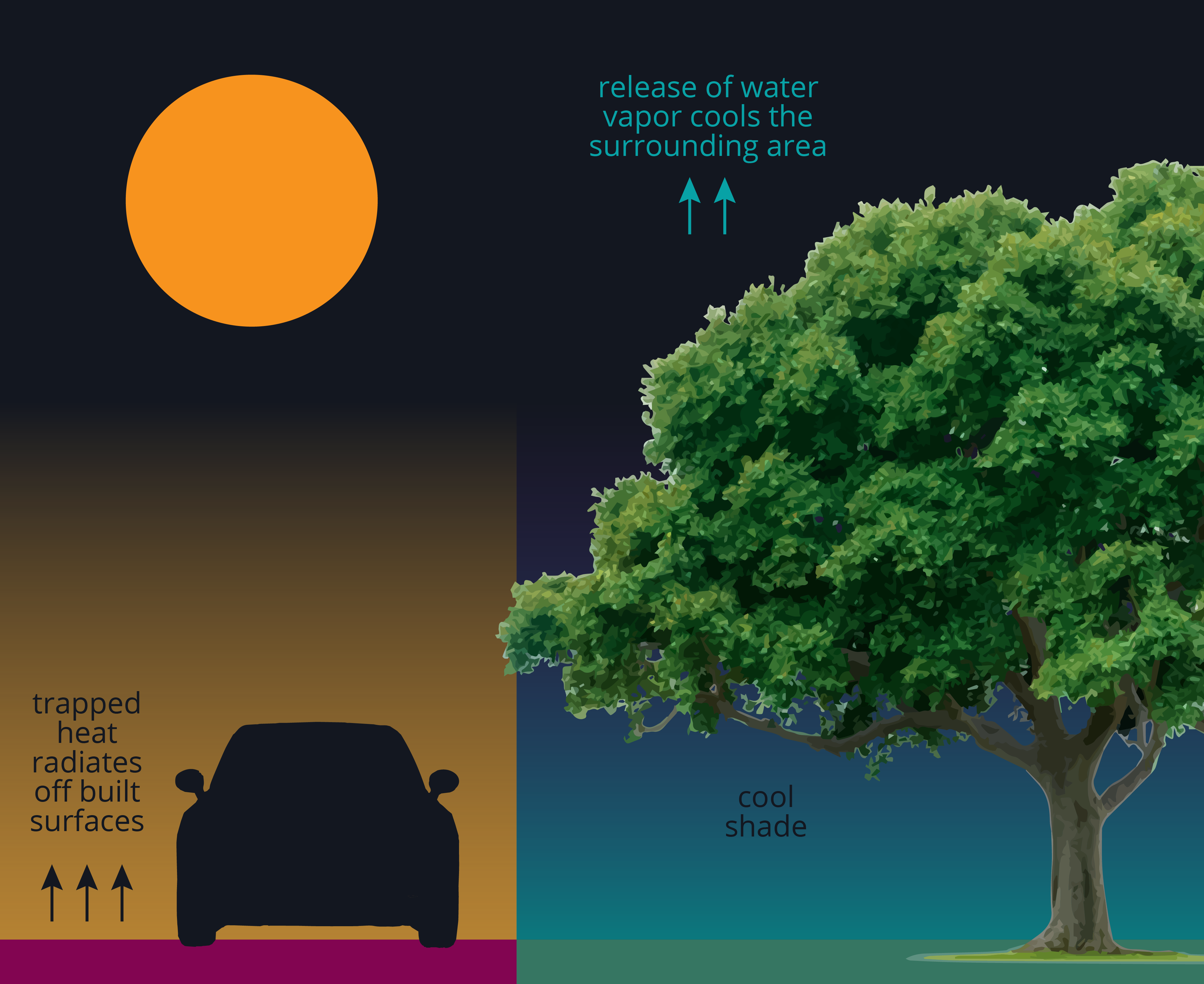
In urbanized areas, built surfaces like roads, asphalt, sidewalks and rooftops absorb and trap heat from the sun. As heat is slowly released back into the air, dangerous islands of heat can form.
Trees can cool our cities by providing shade and by releasing water vapor from their leaves, which cools the air when it evaporates.
Trees can cool our cities by providing shade and by releasing water vapor from their leaves, which cools the air when it evaporates.
Establishing adequate tree cover on a city block can provide up to 10 degrees  of cooling.
We compiled data for every urbanized area1 in America in this interactive table. How many people are impacted by severe urban heat in your area? How many trees does your area need to achieve adequate and equitable tree cover?
Cities are experiencing extreme heat more and more regularly. Climate change is leading to higher temperatures and longer, more intense and more frequent heat waves. Urban heat poses a serious threat to public health, particularly for children, the elderly, people with respiratory illnesses and those who work outdoors.
People with lower incomes and people of color reside disproportionately in the hottest areas of the majority of U.S. cities. With higher incidences of pre-existing health conditions, they are also more vulnerable to heat impacts.
People with lower incomes and people of color reside disproportionately in the hottest areas of the majority of U.S. cities. With higher incidences of pre-existing health conditions, they are also more vulnerable to heat impacts.
Want to know where to plant trees to alleviate the impacts of urban heat?
Interested in more stories? We looked at urban heat equity for every city in America. Explore our U.S.-wide analysis .
Learn More
Tree Equity Score is a free, human-centered, decision-making tool for urban tree plantings used by urban foresters, land-use planners, government officials, neighborhood organizations and many others.
Help make the case for investment in neighborhoods with the greatest need across America using a single, nationwide, neighborhood-level score. Learn more at TreeEquityScore.org.
Help make the case for investment in neighborhoods with the greatest need across America using a single, nationwide, neighborhood-level score. Learn more at TreeEquityScore.org
Methods
American Forests' Tree Equity Score is an analysis of urbanized neighborhoods, where neighborhoods are defined as Census block groups, and urbanized areas are defined by the Census Bureau as “densely developed territory… encompass[ing] residential, commercial, and other non-residential urban land uses.”
Surface temperature data were derived from USGS Earth Explorer Landsat 8 imagery thermal bands. One-meter resolution tree canopy cover for all urbanized areas in the United States was provided by EarthDefine . Temperature and tree canopy maps were created for a cross-section of larger urbanized areas representative of different ecoregions of the United States.
For each urbanized area unit1, the percent of the population living in a heat anomaly was calculated. Urbanized area averages were calculated as the area-weighted mean of all block group mean summer high surface temperatures. A heat anomaly was defined as Census block groups that were 1.25 degrees above average temperatures for the urbanized area and the population tabulated for those block groups.
Tree Equity Score establishes tree canopy targets (percent cover) that are scaled to ecoregions (forest, grassland and desert) and population density, determined in conjunction with the U.S. Forest Service and The Nature Conservancy. The neighborhood canopy gap, GAP, is calculated by subtracting the existing neighborhood canopy from the target. Census block groups were flagged for "adequate tree cover" where GAP = 0, that is, the percent existing tree canopy was greater than or equal to its tree canopy target. Where GAP > 0, the canopy gap % was multiplied by the block group area, then converted to number of trees using a basic multiplier of 600 sq-ft (55.74 sq-m) of canopy area per urban tree assuming a medium-sized, deciduous urban tree crown width of 25-30 ft.
1Census Urbanized Area (UA) units are defined as a continuously built-up area with a population of 50,000 or more, comprising one or more places (e.g., municipalities, cities, towns, villages, or boroughs) and the adjacent densely settled surrounding area (urban fringe) consisting of other places and nonplace territory. The Census Bureau generally merges contiguous urbanized areas when major portions are located in the same metropolitan area (defined by the Federal Office of Management and Budget as a core area containing a large population nucleus, together with adjacent communities that have a high degree of economic and social integration with that core area).
Data
Tree Equity Score, 2022.
Credits
Article and visuals by Julia Twichell.
This American Forests data short was made possible by funding from
All content © 2026 American Forests. Please acknowledge American Forests in the use and distribution of this product. Learn more about American Forests at americanforests.org.
This American Forests data short was made possible by funding from
All content © 2026 American Forests. Please acknowledge American Forests in the use and distribution of this product. Learn more about American Forests at americanforests.org
National Explorer
Local Analyzers
Austin, TX
Boston, MA
Columbus & Franklin County, OH
Dallas, TX
DC region
Detroit, MI
Houston, TX
Indianapolis & Marion County, IN
Lincoln Parish, LA
Maricopa County, AZ
Rhode Island
Richmond, VA
Toronto, ON
Washington State
Learn about AnalyzersInternational
UK
More
About Tree Equity Score
Methods
Data Glossary
FAQs
Data Download
Stories
Watch the Demo
Starter Guide
More Resources
Contact Us
Made possible with tree canopy provided by 
American Forests
1220 L Street, NW,
Suite 750
Washington, DC 20005
American Forests is a nonprofit, tax-exempt charitable organization under Section 501(c)(3) of the U.S. Internal Revenue Code. Donations are tax-deductible as allowed by law.
Copyright © 2026 American Forests. All Rights Reserved. Privacy Policy. Manage Tracking Preferences.
Copyright © 2026 American Forests. All Rights Reserved. Privacy Policy. Manage Tracking Preferences.